I first became aware of the Majorville Medicine Wheel in Alberta aka "Canada's Stonehenge" in the late winter or spring of this year when it was mentioned in a CBC radio program I was listening to. The report spoke about how Gordon Freeman, a chemistry professor at the University of Alberta had written a book titled 'Canada's Stonehenge' in which he put forward his theory that various important astronomical alignments were built into and associated with the Majorville Medicine Wheel. The report interested me because I had always thought that medicine wheels could be depictions of the totally eclipses sun in much the same way that rayed sun petroglyphs. I intended to look into the matter further but was distracted by other things and let it drop.
Just a few weeks ago I was reminded about "Canada's Stonehenge" while doing some research on the internet. I decided to look into it further and soon found the '
Canada's Stonehenge' website after some appropriate Googling around. The "slideshow" at the top of the page showed an image of the cover of the book with an aerial view of the Majorville medicine wheel, a very similar aerial view was portrayed amongst six thumbnail photographs of "Canada's Stonehenge" and the original Stonehenge in England on the top right side of the webpage. I was immediately struck by how this "bird's eye view" of the Majorville medicine wheel distinctly resembled the ancient rayed sun petroglyphs that were inspired by total solar eclipses and I quickly decided that it was highly probable that the "
Canada's Stonehenge"
medicine wheel was a gigantic geoglyph version of such "compound sun/eye symbol" petroglyphs which was fully intended to be viewed from the sky, just like the Nazca Lines biomorph geoglyphs in Peru and other geoglyphs and effigy mounds in North America are clearly meant to be viewed from above. I was quite certain that the large central cairn surrounded by rays was intended to represent the total solar eclipse "Eye of God" just as the very similar, indeed almost identical,
"compound sun/eye symbol" petroglyphs that are carved into Ireland's prehistoric '
The Stone Of The Seven Suns' at the
Dowth Passage Tomb almost certainly do.

I decided to do some initial research into when a concentrated series of total solar eclipses took place at or near "Canada's Stonehenge", being quite certain that it was simply a question if "when" not "if" in lught of the fact that it was supposed to be five thousand years old. It took some more browsing through the website, and some additional Google searches, to get an idea of where "Canada's Stonehenge" was located in Alberta. I did not initially know that it was called the
Majorville medicine wheel, and I did not know where Majorville was when I did find that out. Once I found out that Majorville was southeast of Calgary I began to have a look at NASA maps of the paths of solar eclipses to see what total solar eclipses and annular eclipses occurred over Majorville or near it. I knew that the Majorville medicine wheel was supposed to be five thousand years old, and I also knew that NASA's map of solar eclipse paths only goes back four thousand years to 2000 BCE but I decided to work with what I had available. I knew that even if the Majorville medicine wheel had been originally inspired by a 5000 year old series of total solar eclipses in its environs, something that is not necessarily the case, that later series of solar eclipses would have had an important influence and may have inspired the Indians who built the medicine to modify it so that it looked like a gigantic drawing of a total solar eclipse, indeed what I call the total solar eclipse "Eye of God" when viewed from the sky.

Imagine my gratification when the very first NASA map of solar eclipse paths that I looked at, obviously the earliest one available from
2000 BCE to 1981 BCE showed a total solar eclipse path of totality running down through what is now Alaska and British Columbia into Montana and crossing the USA to the east coast. That total solar eclipse would have been visible just a few hundred miles west of the site of "Canada's Stonehenge". It took place on
October 25 1988 BCE. The path of an annular eclipse of the sun, the ringlike type of solar eclipse that takes place when the moon is too far away from the Earth to totally eclipse the sun, ran right alongside much of this path of totality to the east of it from Alaska and the Yukon, through British Columbia and southwestern Alberta, and across all of Montana. This annular solar eclipse occurred on
August 12 1984 BCE less than four years after the 1988 BCE total solar eclipse and its path was even closer to Majorville as depicted on the NASA map. As if this was not enough, a third solar eclipse path was shown crossing both of these two eclipse paths from west to east (or east to west if you prefer) near the southeastern part of British Columbia and across southern Alberta, southern Saskatchewan and mid Manitoba. This solar eclipse was a rare hybrid solar eclipse which is a solar eclipse which appears as an annular eclipse at both extremities of its path of totality, but is also a brief total solar eclipse in the middle part of the path of totality.
Hybrid solar eclipses occur when the angular diameters of the sun and moon are virtually identical.
A hybrid eclipse is total on those parts of the globe that are closest to the sun and moon but turns into a thin-ringed annular eclipse on those parts of the globe that are farther away from the sun and moon. This hybrid solar eclipse took place on
July 23 1993 BCE and thus was the first eclipse in this series of eclipses over southern British Columbia and Alberta. It preceded the October 28 1988 BCE total solar eclipse by just over five years and may have regenerated interest in observing solar eclipses, if not attempts to predict them, in the Indians who maintained the Majorville medicine wheel Sun Temple.
The upshot of all this is that about one thousand years after the Majorville medicine wheel is believed to have been first constructed, the Indians in south western Alberta and south eastern British Columbia had the opportunity to witness three major solar eclipses within a time span of just over one decade. It is kind of fun that all four types of solar eclipses were represented by these three solar eclipses. The first eclipse of 1993 BCE being a rare
hybrid solar eclipse which appeared in the sky as a thin (and quite brief) annular eclipse soon after sunrise, the second eclipse being the dramatic total solar eclipse on the afternoon of October 28 1988 BCE, and the third eclipse being the annular eclipse which would have been seen in the west around sunset on August 12 1984 BCE.
What is the fourth type of solar eclipse you ask?
Nothing special, just the partial solar eclipses which would have been witnessed by those people who were outside of the paths of totality or annularity of these three solar eclipses. I say "nothing special" because partial solar eclipses simply cannot compare to high drama and cosmic symbolism of total solar eclipses, or even beautiful annular solar eclipses (which are of course a form of partial solar eclipse in that the sun is never totally eclipsed during one), but I expect that even a thin partial solar eclipse would have impressed those people who were not *too* far outside of the path of totality, especially if it occurred near sunrise or sunset. Indeed to the Plains Indians the thin crescent of partially eclipsed sun may have been thought of as a beautiful golden bow or even the golden horns of a cosmic solar buffalo. . .
Did I forget to mention that the very next NASA map that I looked at, which mapped all of the total and annular solar eclipse paths from
1980 BCE to 1961 BCE, showed that a total solar eclipse took place very close to Canada's Stonehenge on the "official" day of the Vernal Equinox on
March 21 1968 BCE? Gordon Freeman would tell you that the *real* Equal-Night Day quite literally observed by the ancient astronomers he calls SkyWatchers who maintained the Majorville Medicine Wheel Sun Temple actually took place several days earlier on March 17th, none-the-less it must have seemed especially significant to have a total solar eclipse occur so close to what we call the Spring Equinox. Likewise it would have probably seemed of special significance if a major solar eclipse occurred on or near either the winter or summer solstice, as some solar eclipses did.
Without further ado here is the full text of the first email that I sent to amateur archaeoastronomer Gordon Freeman, the author of 'Canada's Stonehenge', on August 18th after speaking with him during my first impromptu phone conversation that began around 9:30 the night before, and which lasted for well over fifteen minutes and maybe as much as a half-hour or so. I will be blogging about later conversations and written communications in the coming weeks and months with Gordon Freeman's kind permission to share everything openly. This initial letter is not terribly exciting but it gives a brief overview of the solar eclipses that occurred at or reasonably near to "Canada's Stonehenge". For the record Gordon Freeman is not overly thrilled with that designation of the Majorville Medicine Wheel and its related astronomical alignments, and neither am I, although it is beginning to grow on me. . . There are some pretty good reasons to use that title but other good reasons not too. I may use it less as time goes on but I am using it extensively now if only to help ensure that those people interested in "Canada's Stonehenge" will have a better chance of finding this blog post when searching for that term in Google and other search engines. Yes, some people actually use other search engines on occasion. ;-)
It should be noted that there are some apparent comparatively minor errors in this initial communication with Gordon Freeman. For starters I mixed up NASA's somewhat arcane dating system with true BCE (Before Current Era) so it is necessary to add a year to the dates marked XXXX BCE to get the true BCE date. Also. . . the very detailed Google Maps of the paths of totality of the individual eclipses follow paths that are somewhat different from those depicted on the maps that show the paths of total and annular solar eclipses over twenty year time spans. I only discovered this today when I looked at a one of the Google Maps of a path of totality and saw a clear discrepancy with same path of totality depicted on the more general purpose 20 year span maps. The much more detailed, and presumably (albeit not necessarily. . .) more accurate, Google Maps versions of paths of total and annular solar eclipses seem to be quite consistently shifted a few hundred miles further to the east than the "general purpose" ones. Needless to say this actually works in my favor in terms of the three paths of totality that were depicted as being somewhat to the west of the Majorville medicine wheel. :-) So some solar eclipses that I had thought occurred directly above "Canada's Stonehenge" actually occurred a few hundred miles to the east of the site, at least according to the more detailed Google Maps, but this is compensated for by the fact that solar eclipses that I had thought took place to the west of the site actually took place directly over it if we put our trust in the reliability and accuracy of the Google Maps versions of paths of totality. More about that later in another blog post.
My first email to Gordon Freeman -
Some Initial Research Into Total Solar Eclipses Observable Near Canada's Stonehenge
Tuesday, August 18, 2009 2:37 AM
(Author's note: Yes I was burning the midnight oil. . .)
From: "Robin Edgar" robinedgar59@yahoo.ca
To: XXXX@ualberta.ca
Hi Gordon,
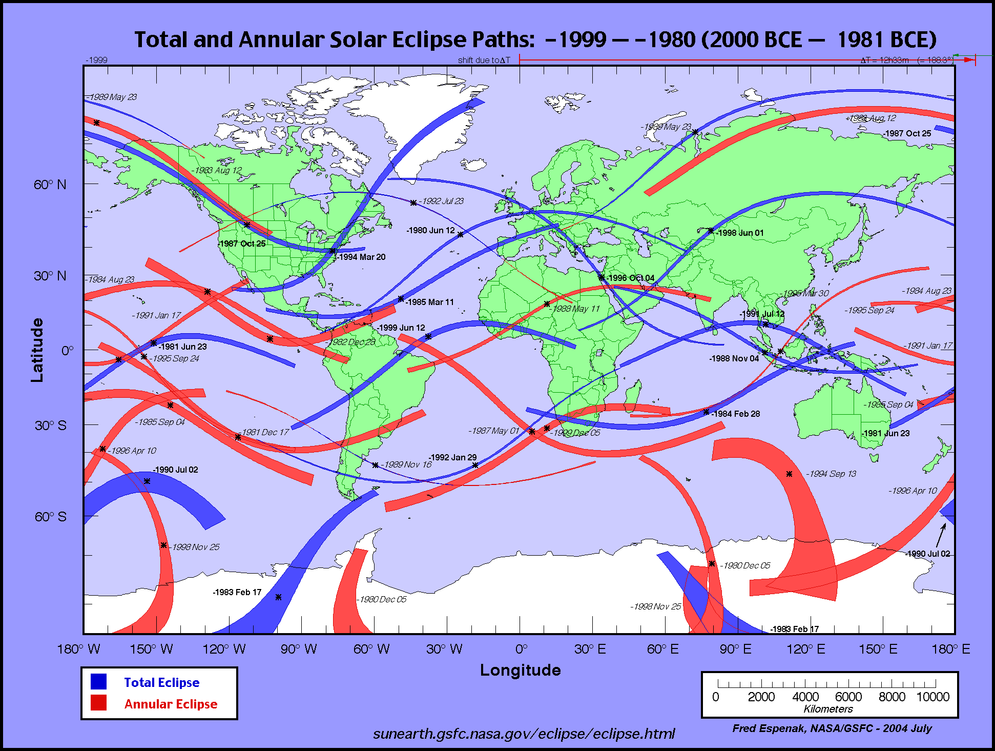
After our initial phone conversation of Monday evening in which I suggested that the Majorville solar effigy "medicine wheel" may have been inspired by observations of total solar eclipses and that the related solar and lunar alignments that you have discovered may have been used to try to predict eclipses, I decided to browse through NASA maps of the paths of totality of total solar eclipses, and the paths of "annularity" of annular (ring-like) solar eclipses, to determine which total solar eclipses and annular eclipses would have been observable at or near what you call Canada's Stonehenge. Unfortunately the NASA maps only go back as far as -1999 BCE and thus do not go back a full 5000 years but the results were quite interesting none-the-less. In fact a number of significant paths of totality passing over the Majorville solar effigy site, or very close to it, were found in the earliest maps!
Herewith is a recounting of what I found -
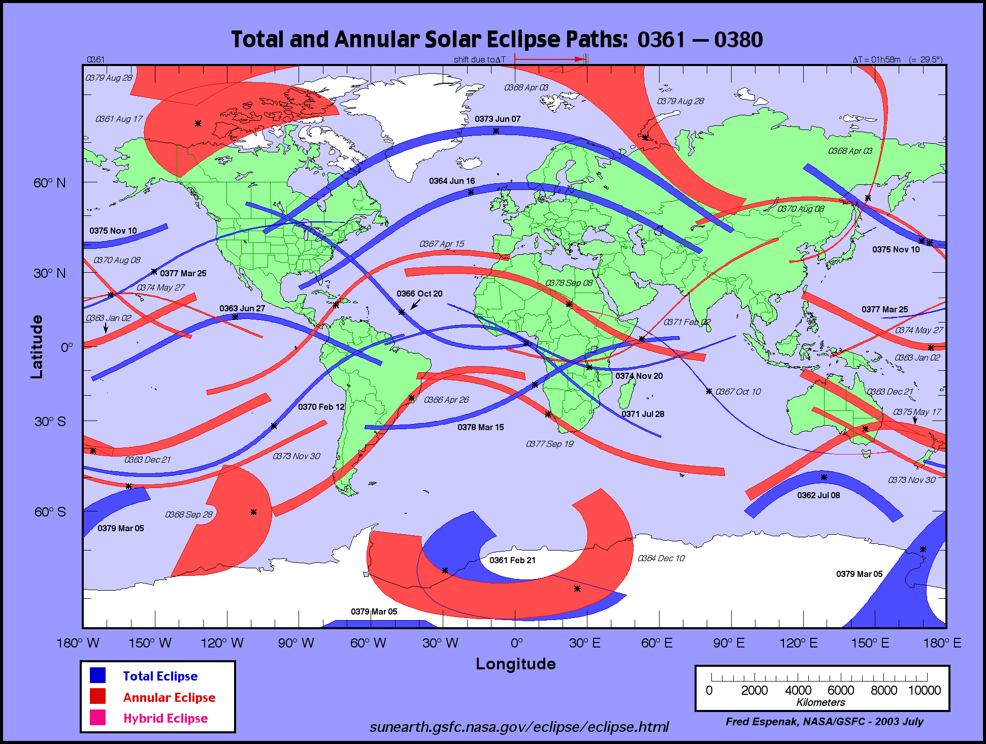
NASA maps of the paths of totality of total solar eclipses only go back as far as 1999 BCE but interestingly enough there are two annular eclipses shown over what is now southern Alberta in the very first map. The first annular eclipse was the annular part of a hybrid eclipse (part total part annular due to sun and moon have near identical angular diameters at the time of the eclipse) which took place on July 23, 1992 BCE. The second annular eclipse was the solar eclipse of August 12, 1983 BCE. On October 25, 1987 BCE, a total solar eclipse took place with the path of totality (POT) passing to the west and south of the Canada's Stonehenge sun effigy "medicine wheel" at Majorville in what is now south eastern British Columbia and Montana.
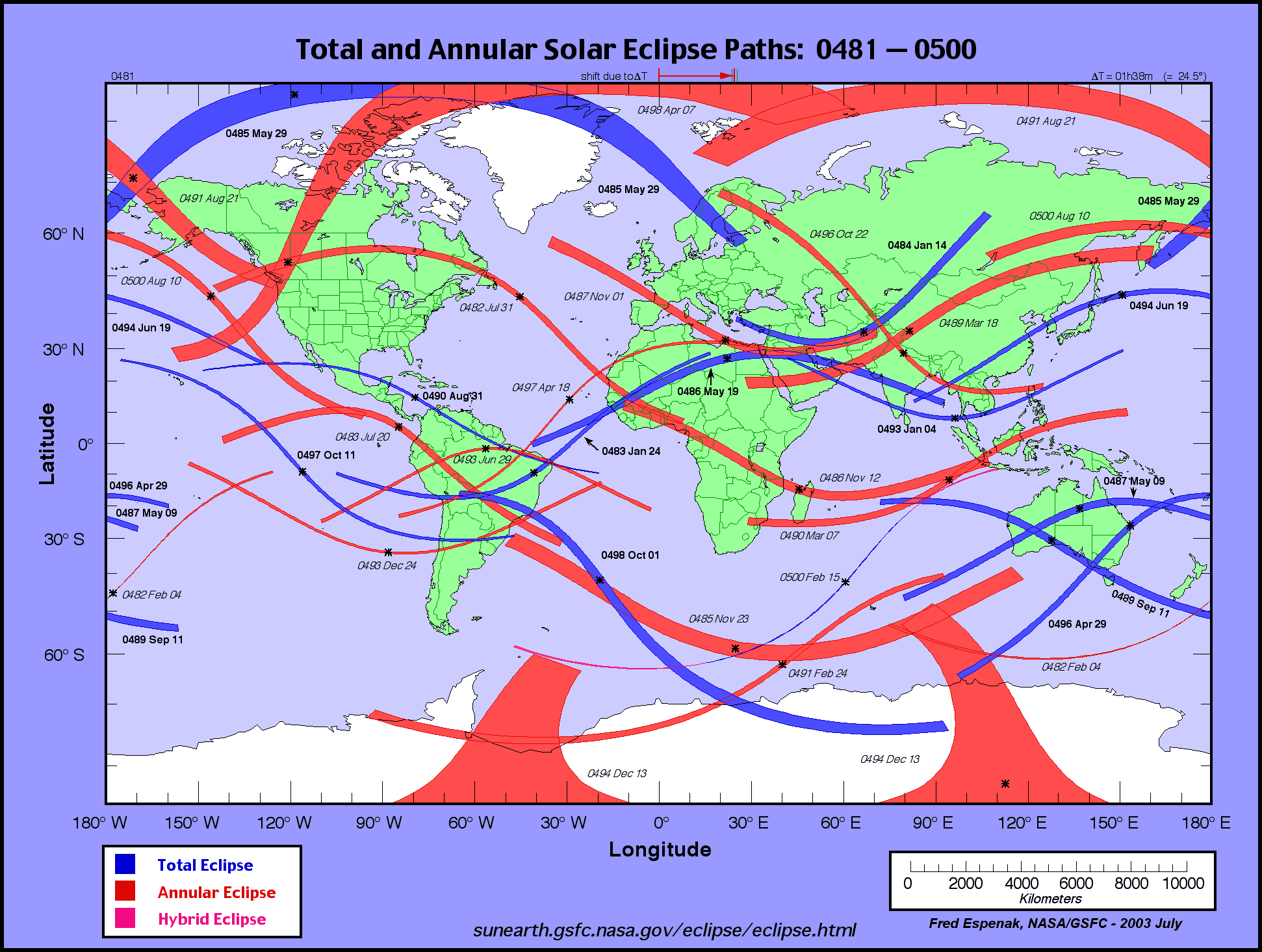
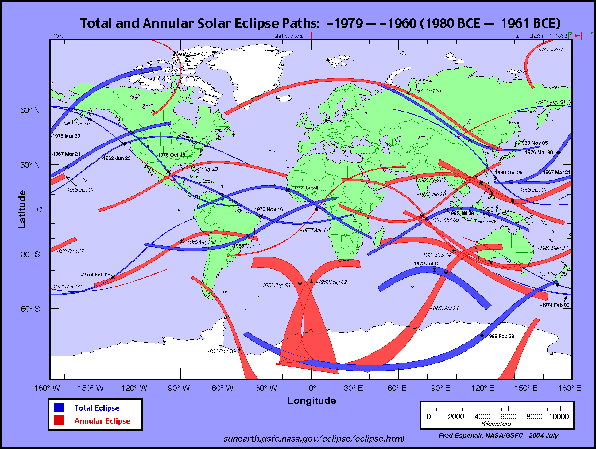
http://eclipse.gsfc.nasa.gov/SEatlas/SEatlas-2/SEatlas-1999.GIFOn March 21, 1967 BCE, a total solar eclipse occurred somewhat to the north of the Majorville sun effigy. On June 23, 1962 BCE, a total solar eclipse occurred soon after the summer solstice in what is now Montana.
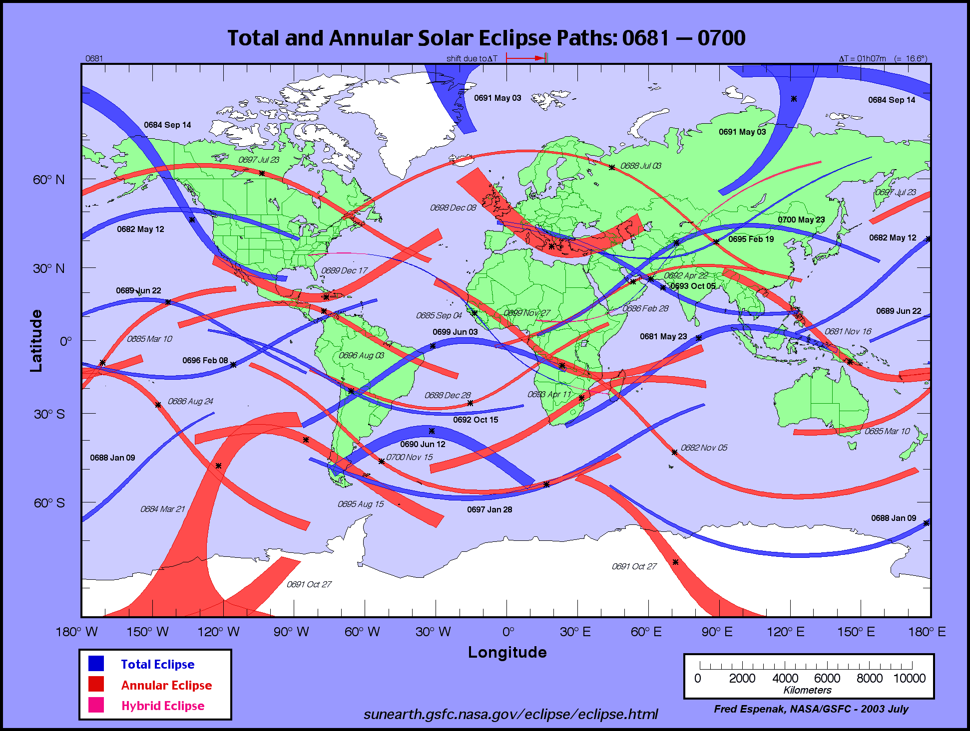
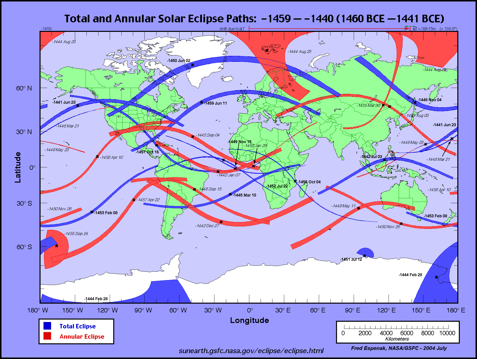
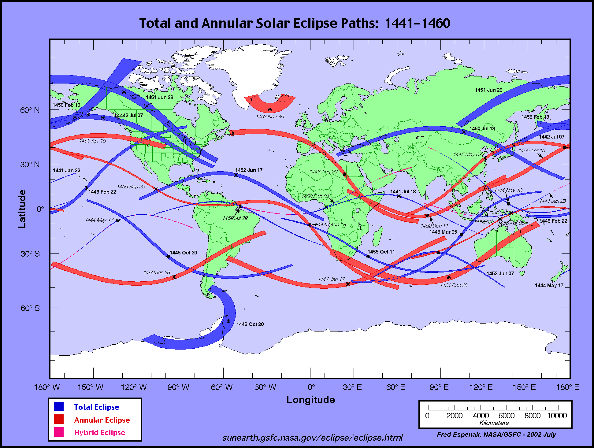
http://eclipse.gsfc.nasa.gov/SEatlas/SEatlas-2/SEatlas-1979.GIFAnother summer solstice total solar eclipse took place somewhat to the north of your site on June 23, 1441 BCE. This total solar eclipse (TSE) was preceded by two total solar eclipses whose paths of totality overlapped over what is now southwestern Montana. The path of totality of the of October 15, 1457 BCE, total solar eclipse was considerably to the south of the Majorville cairn but perhaps not *too* far away for some word of mouth cultural contact to bring news of it, while the path of totality of the June 02, 1450 BCE, cut a swath from southwest Montana through north east Montana. All three of these total solar eclipses would have been seen as very strong partial eclipses at the actual site of the Majorville cairn/sun effigy but one or two of them were likely witnessed by Indians who were in the actual paths of totality not all that far from where the sun effigy is located.
http://eclipse.gsfc.nasa.gov/SEatlas/SEatlas-2/SEatlas-1459.GIFAbout 500 years later the path of totality of the
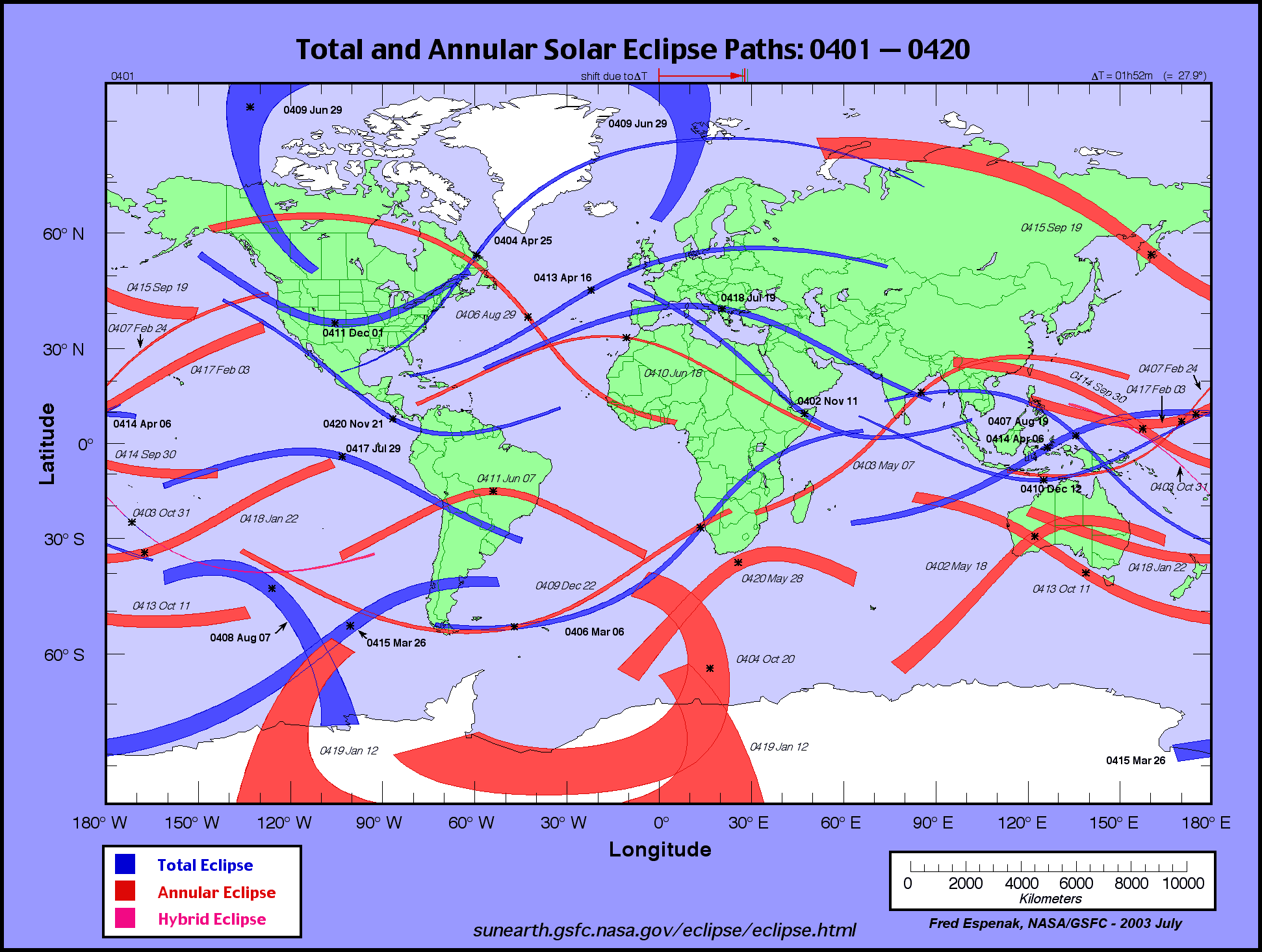
May 11, 965 BCE, total solar eclipse cut a wide swath across North America from the coast of B.C. through southern Alberta, southern Saskatchewan, southern Manitoba, southern Ontario, southern Quebec, Maine and southern Nova Scotia. It would seem that the southern edge of the path of totality would have been not far to the north of the sun effigy if not directly over it.
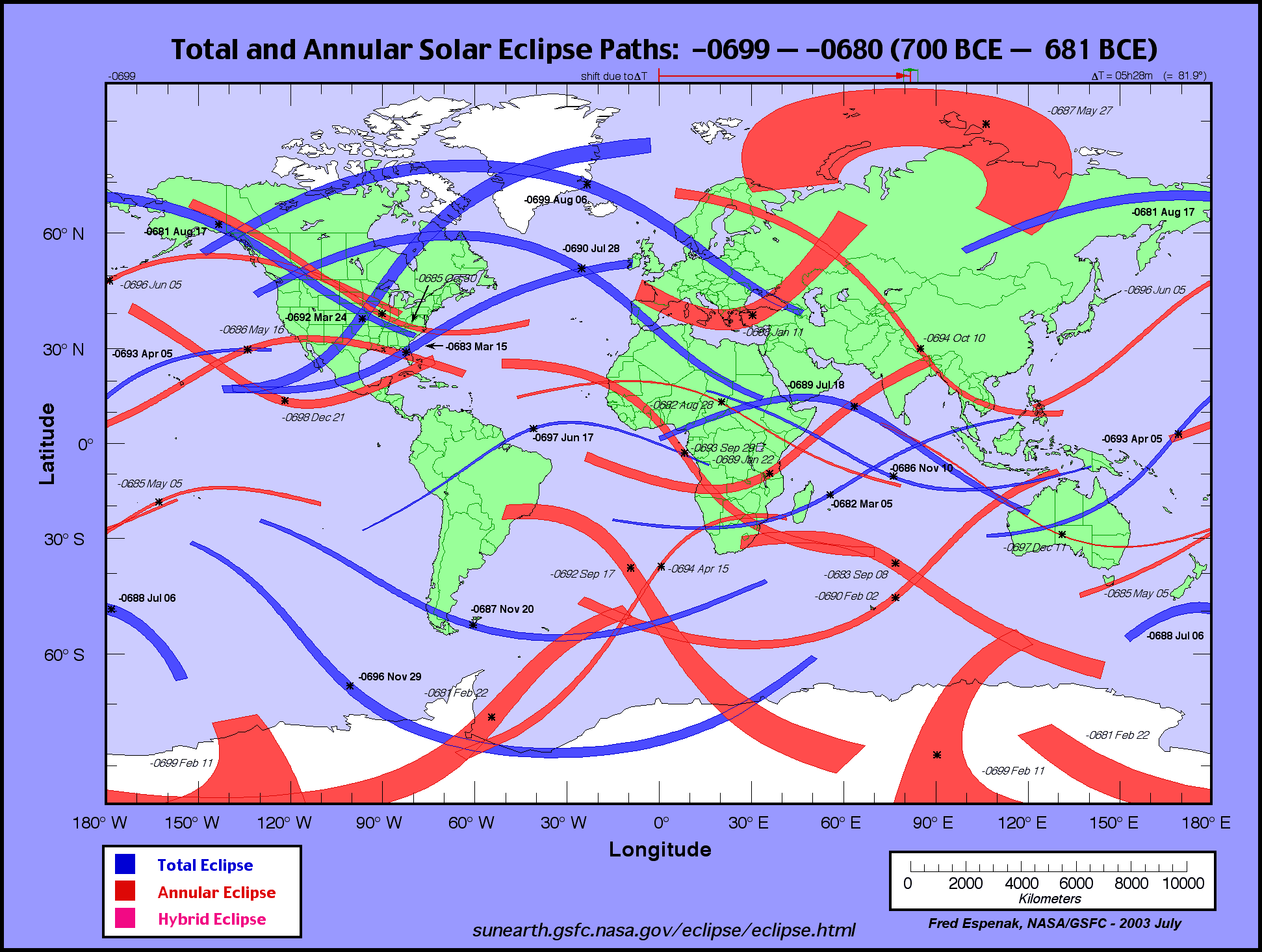
http://eclipse.gsfc.nasa.gov/SEatlas/SEatlas-1/SEatlas-0979.GIFTwo total solar eclipses occurred over southeastern B.C. and southwestern Alberta within a decade. The first on
July 28, 690 BCE, and the second on August 17, 681 BCE. Two annular solar eclipses took place directly over or very close to the Majorville sun effigy medicine wheel within the same generation. The first occurred on
June 05, 696 BCE, and the second on
October 30, 685 BCE.
http://eclipse.gsfc.nasa.gov/SEatlas/SEatlas-1/SEatlas-0699.GIFThe total solar eclipse of
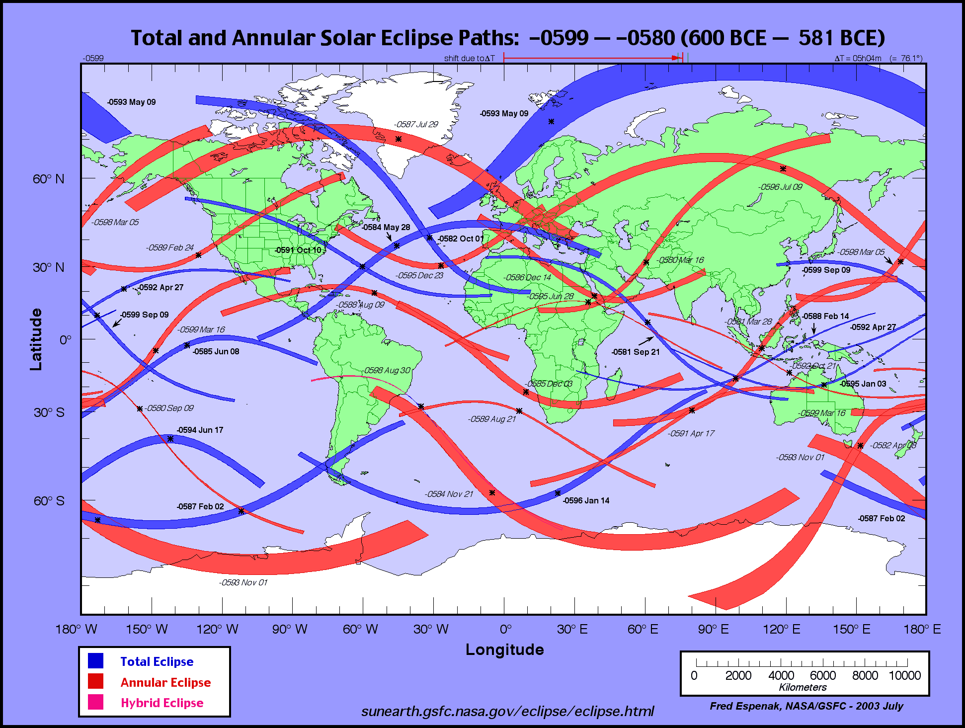
October 10, 591 BCE, occurred directly over or very close to the Majorville sun effigy medicine wheel.
http://eclipse.gsfc.nasa.gov/SEatlas/SEatlas-1/SEatlas-0599.GIFThe POT (path of totality) of the
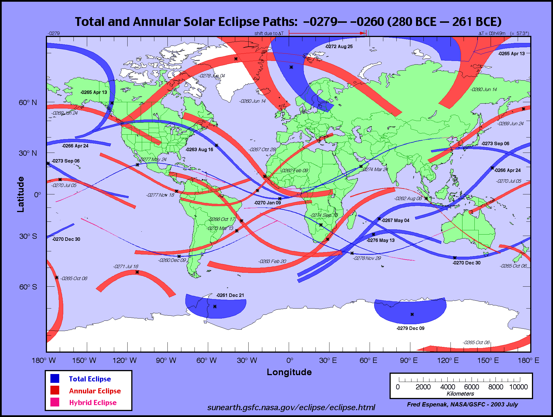
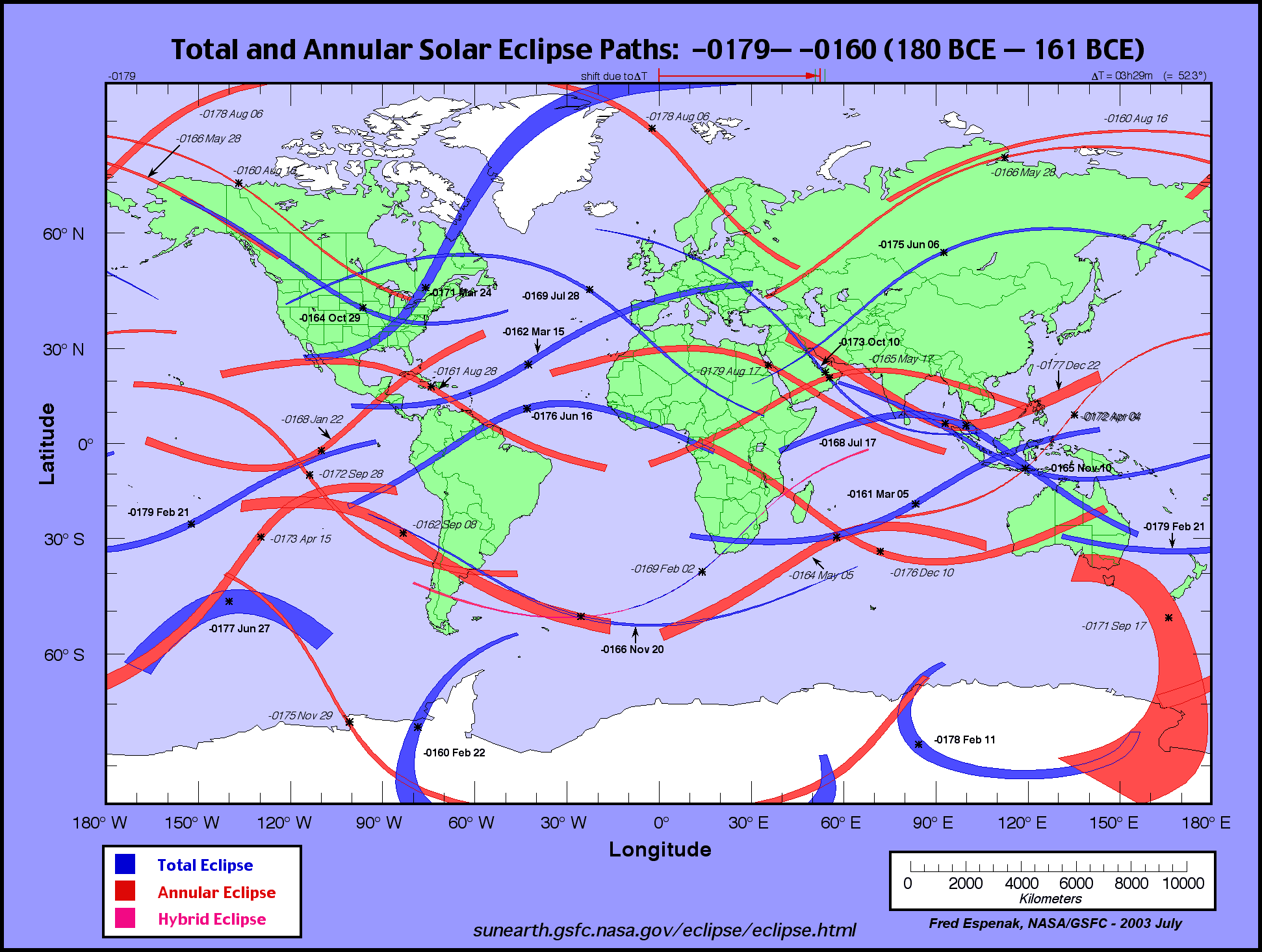
August 16, 263 BCE, total solar eclipse would appear to have passed over the Majorville sun effigy.
http://eclipse.gsfc.nasa.gov/SEatlas/SEatlas-1/SEatlas-0279.GIFThe southern edge of the POT (path of totality) of the
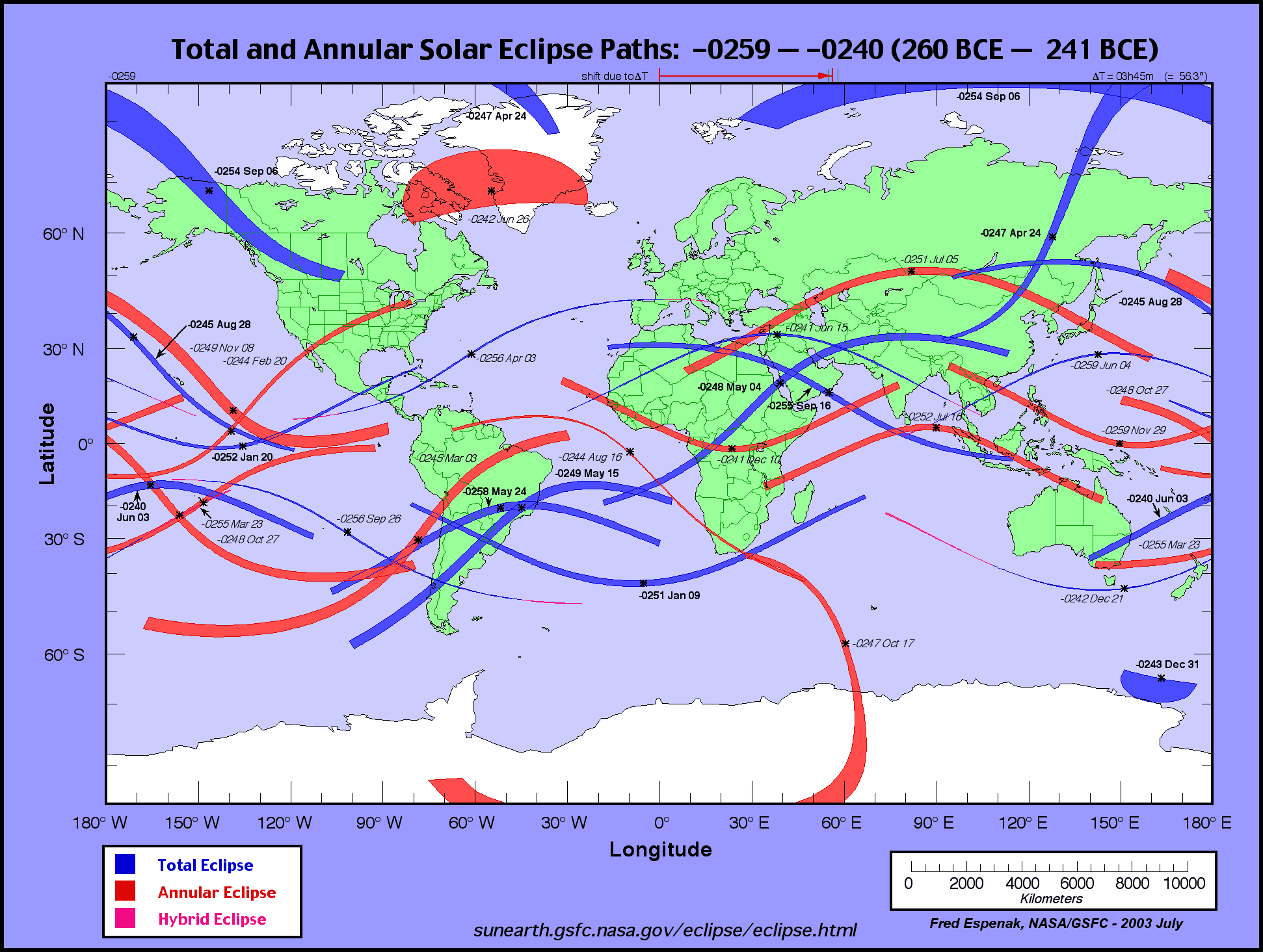
September 6 254 BCE total solar eclipse would appear to have passed over the Majorville sun effigy, making two total solar eclipses observable at or very near Canada's Stonehenge within the space of just over 11 years.
http://eclipse.gsfc.nasa.gov/SEatlas/SEatlas-1/SEatlas-0259.GIFLess than a century would pass before another total solar eclipse would be observable not far to the south of the Majorville sun effigy when the POT of the
October 29, 164 BCE, total solar eclipse would pass over southern Alberta. It would have been preceded by the
July 28, 169 BCE, total solar eclipse which cut a swath across Montana and may have served as something of a "heads up" for the subsequent eclipse. Any Native Americans living in the area of central Montana where the two paths of totality criss-cross on the NASA map would potentially witness two total solar eclipses within 5 years or so. . .
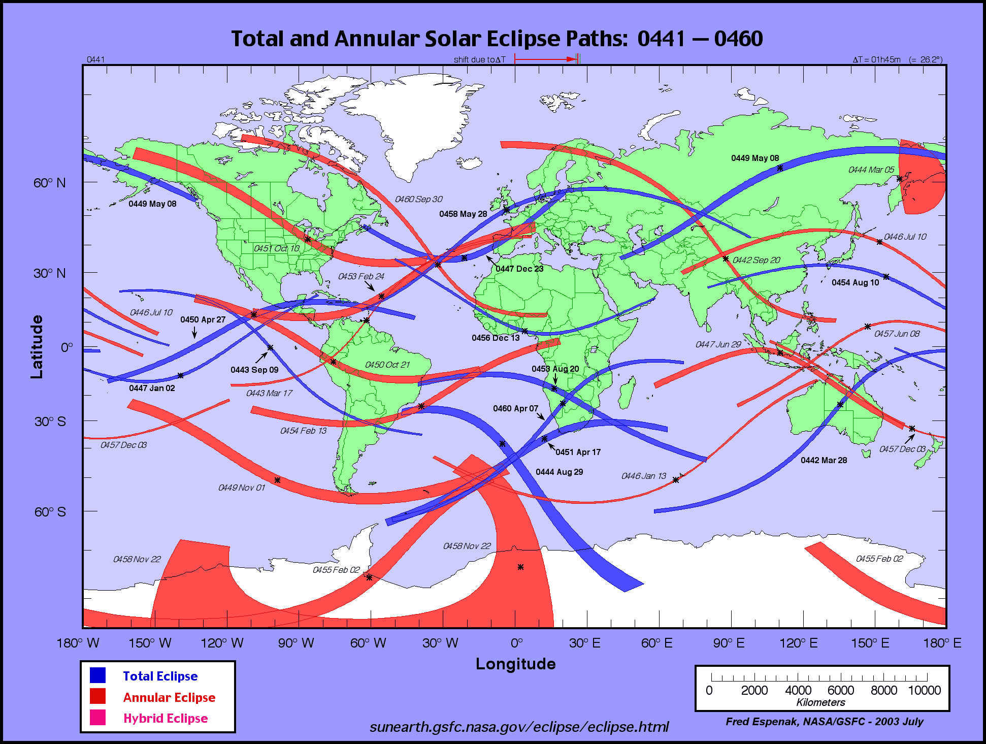
http://eclipse.gsfc.nasa.gov/SEatlas/SEatlas-1/SEatlas-0179.GIFIt would seem that, less than a decade after the October 29, 164 BCE, total solar eclipse, a hybrid eclipse that would have appeared as a total solar eclipse above or very close to the Majorville sun effigy took place on
Octber 20, 155 BCE. Its path of totality appears to have been a very thin one so it is not clear how many people would have actually witnessed totality even if observing conditions were perfect but this hybrid eclipse would have been seen as a very strong, almost total, partial solar eclipse in the area around the sun effigy none-the-less and a privileged few people might have observed the very brief total phase of this hybrid solar eclipse. Eleven years later the path of totality of the
March 25, 144 BCE, total solar eclipse cut a wide swath across southern Alberta.
http://eclipse.gsfc.nasa.gov/SEatlas/SEatlas-1/SEatlas-0159.GIFThus, within a span of about twenty years, three total solar eclipses took place directly above (or very close to) the Canada's Stonehenge sun effigy "medicine wheel" which, as I said in our phone conversation, is very likely to be a geoglyph that graphically represents the totally eclipsed sun surrounded by the rays of the sun's corona. I am quite convinced that the solid 10 meter diameter central mound of rocks represents the moon eclipsing the sun during a total solar eclipse or is a "composite" image of the sun surrounded by the rays of the corona that are only seen during totality. Compare the aerial photograph of the sun effigy with the two images of the 2001 total solar eclipse and the petroglyphs that were carved into 'The Stone Of The Seven Suns' at Dowth about five thousand years ago -
http://www.flickr.com/photos/canadastonehenge/3075075644/http://www.mythicalireland.com/ancientsites/dowth/sevensuns-slide1.jpg
http://www.williams.edu/Astronomy/eclipse/eclipse2001/2001total/2001composites/wcjp01litesun.htmhttp://www.williams.edu/Astronomy/eclipse/eclipse2001/2001total/2001composites/wcjp01lite%2B100%25sun.htmAs they say. Seeing is believing. . .
The compound sun/eye symbol petroglyphs that were carved into 'The Stone Of The Seven Suns' at Dowth are almost certainly ancient rock art drawings of the totally eclipsed sun, and the Canada's Stonehenge sun effigy is strikingly similar to these and numerous other rayed sun symbols that were inspired by ancient observations of the sun's corona during total solar eclipses.
Back to the fray -
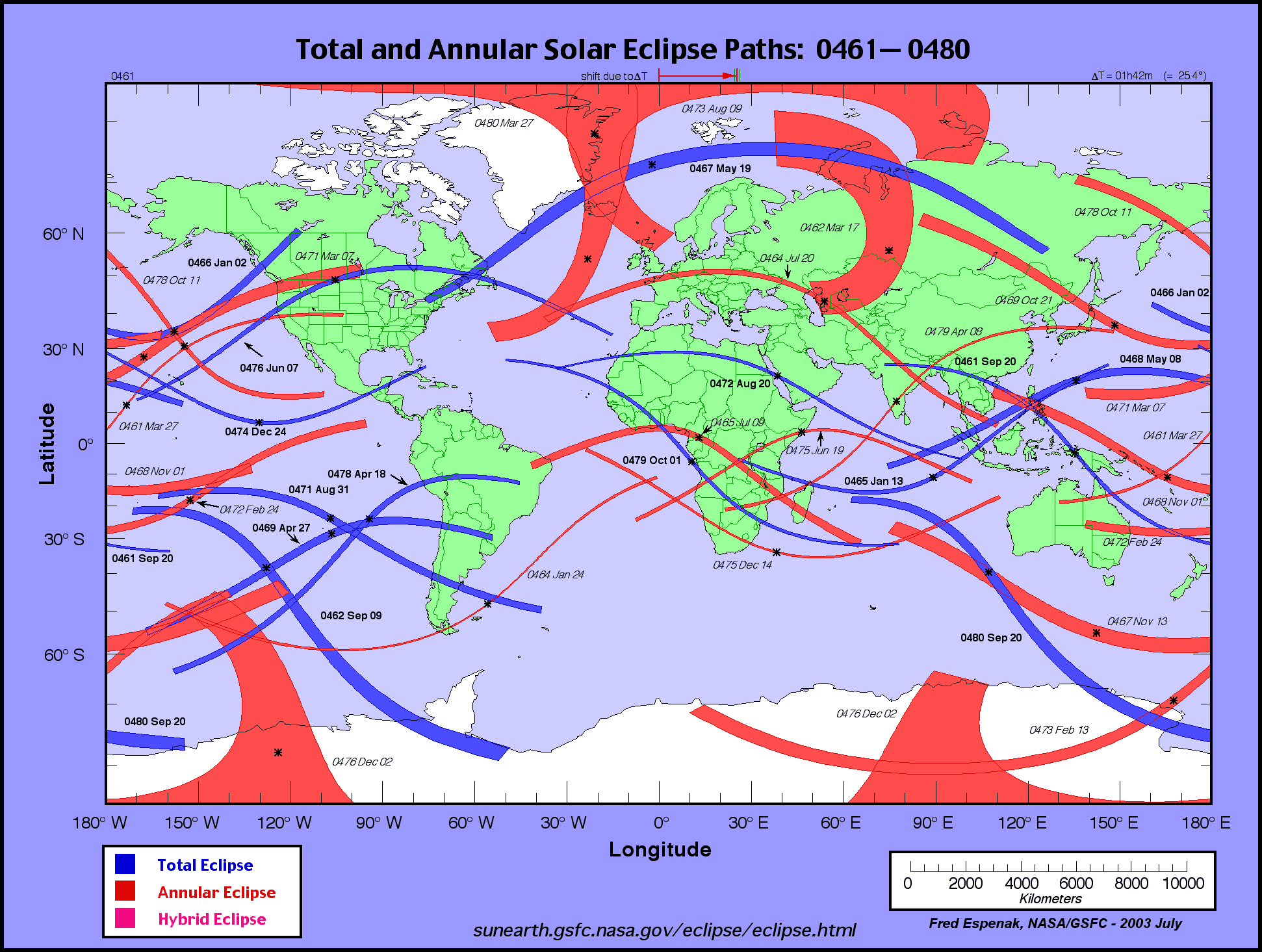
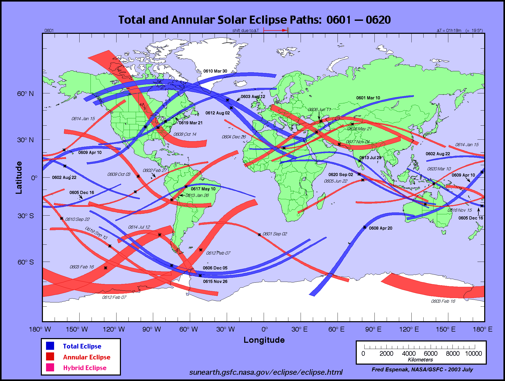
It seems that the next total solar eclipse occurring near the Canada's Stonehenge sun effigy did not take place until
September 13, 657 AD about 800 years down the road. . . The path of totality cut a swath across Canada starting in what is now central southern B.C. all the way to what is now Nova Scotia. It looks like the southern edge of the path of totality would have been a bit to the north of Canada's Stonehenge.
http://eclipse.gsfc.nasa.gov/SEatlas/SEatlas1/SEatlas0641.GIF25 years later the path of totality of the
May 12, 682 AD, total solar eclipse cut across what is now southern British Columbia and traversed Montana from northwest to southeast. It thus would have been some hundreds of miles south of Canada's Stonehenge but it is not unreasonable to propose some cultural contact may have brought news of it to the Indians of southern Alberta who would have seen it as a strong partial eclipse.
http://eclipse.gsfc.nasa.gov/SEatlas/SEatlas1/SEatlas0681.GIFOn
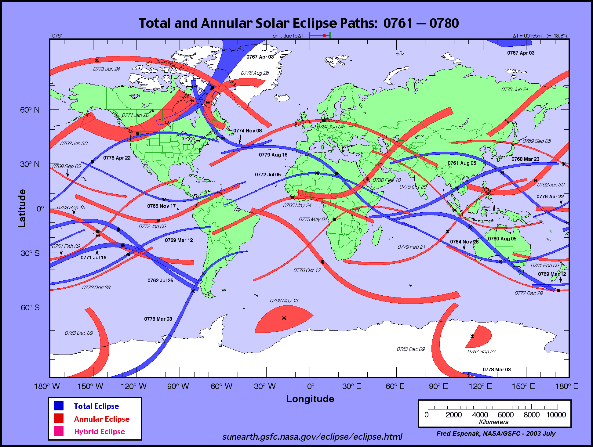
January 20, 771 AD, an annular eclipse was seen over much of southern Alberta and northern Montana. Just over 5 years later, the path of totality of the
April 22, 776 AD, total solar eclipse traversed northern Montana.
http://eclipse.gsfc.nasa.gov/SEatlas/SEatlas1/SEatlas0761.GIFThe path of totality of the
May 16, 858 AD, total solar eclipse cut a path across Canada from Vancouver Island to Nova Scotia. This total solar eclipse would have been observable somewhat to the north of Canada's Stonehenge.
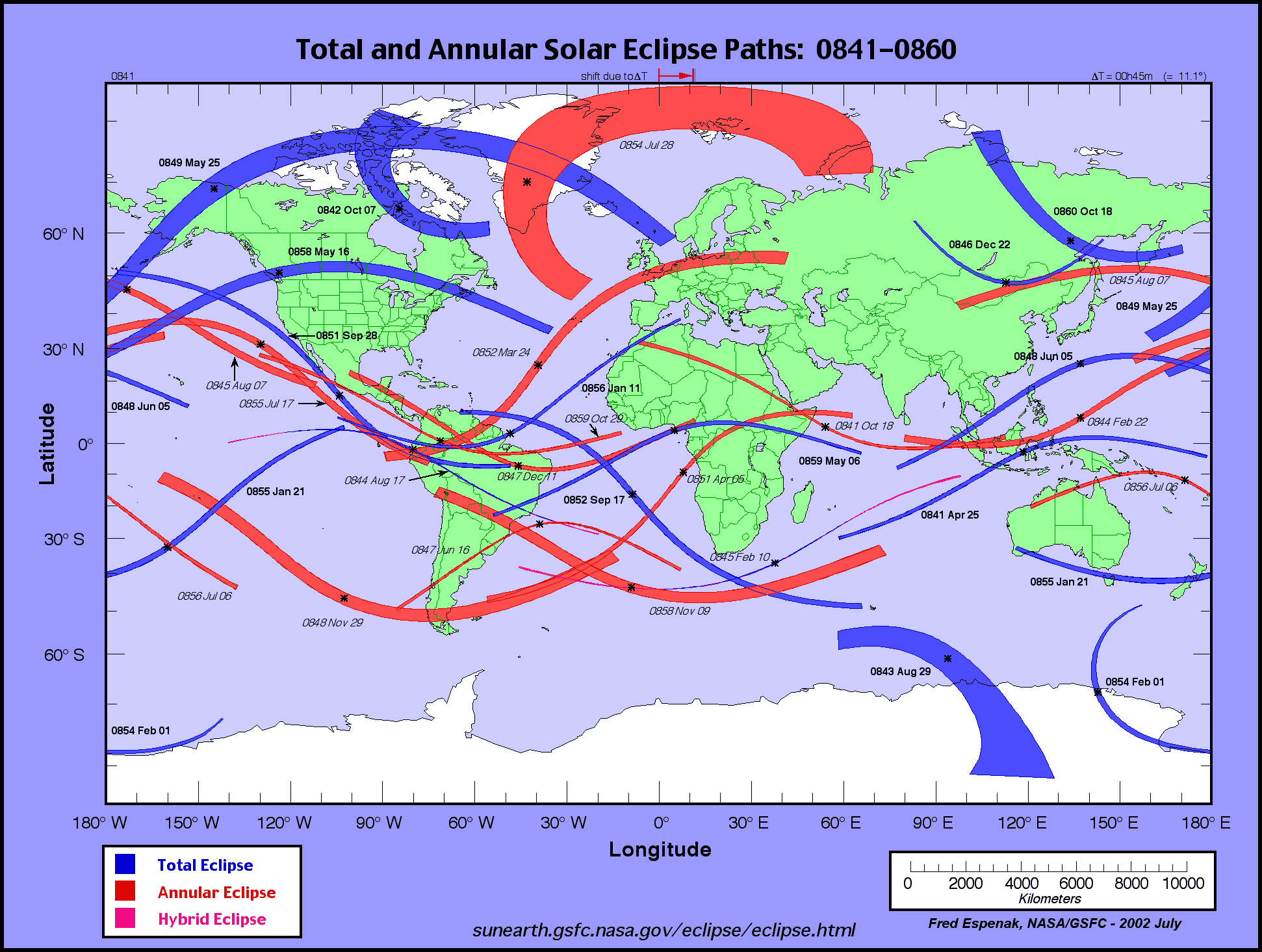
http://eclipse.gsfc.nasa.gov/SEatlas/SEatlas1/SEatlas0841.GIFLess than forty years later on
November 8, 896 AD, another total solar eclipse would have been observable somewhat to the north of Canada's Stonehenge.
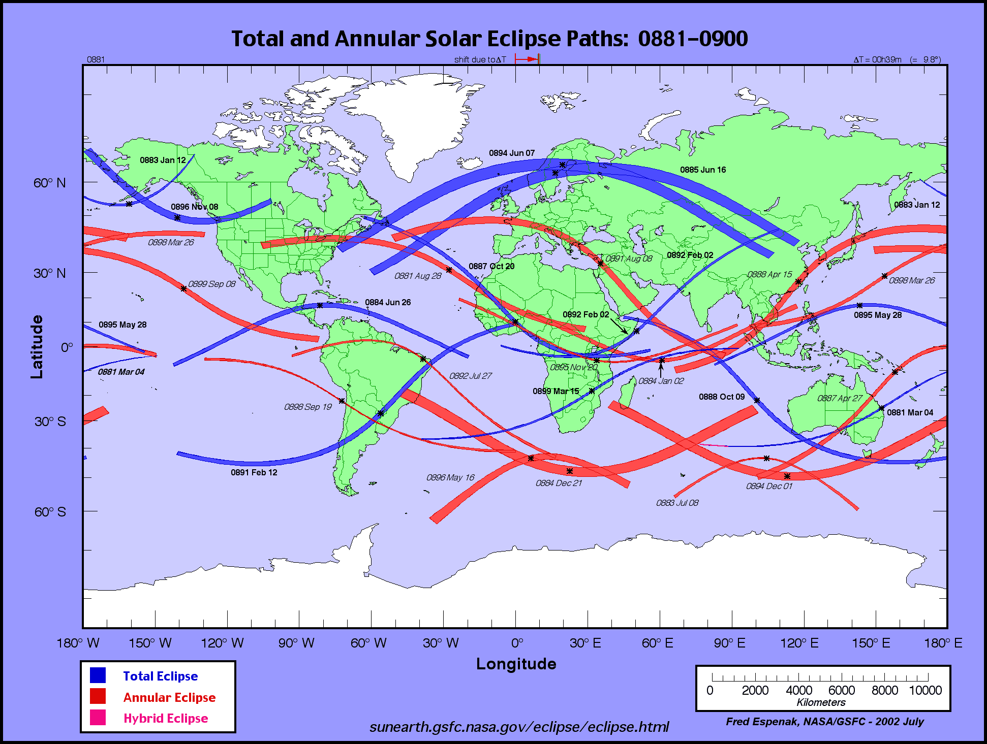
http://eclipse.gsfc.nasa.gov/SEatlas/SEatlas1/SEatlas0881.GIFThis NASA map at the URL below is worth a look. Although the overlapping total and annular eclipse paths are somewhat to the north of Canada's Stonehenge it is quite possible that one or both were witnessed by Indians from the same tribe or a different tribe that had cultural contact with the Indians who built and maintained Canada's Stonehenge.
http://eclipse.gsfc.nasa.gov/SEatlas/SEatlas1/SEatlas0901.GIFIn the first half of the 11th century several annular eclipses occurred over southern Alberta.
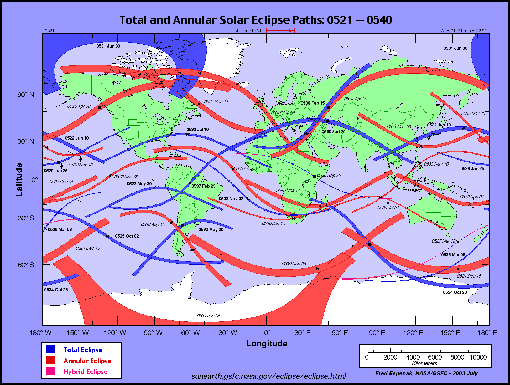
The path of totality of the
July 07, 1442 AD, total solar eclipse passed directly over the Majorville sun effigy or just to the south of it and descended into Montana. The path of totality of the
February 22, 1449 AD, TSE traversed Montana from southwest to northeast. The Indians in central Montana were treated to two total solar eclipses within seven years.
http://eclipse.gsfc.nasa.gov/SEatlas/SEatlas2/SEatlas1441.GIFThe path of totality of the
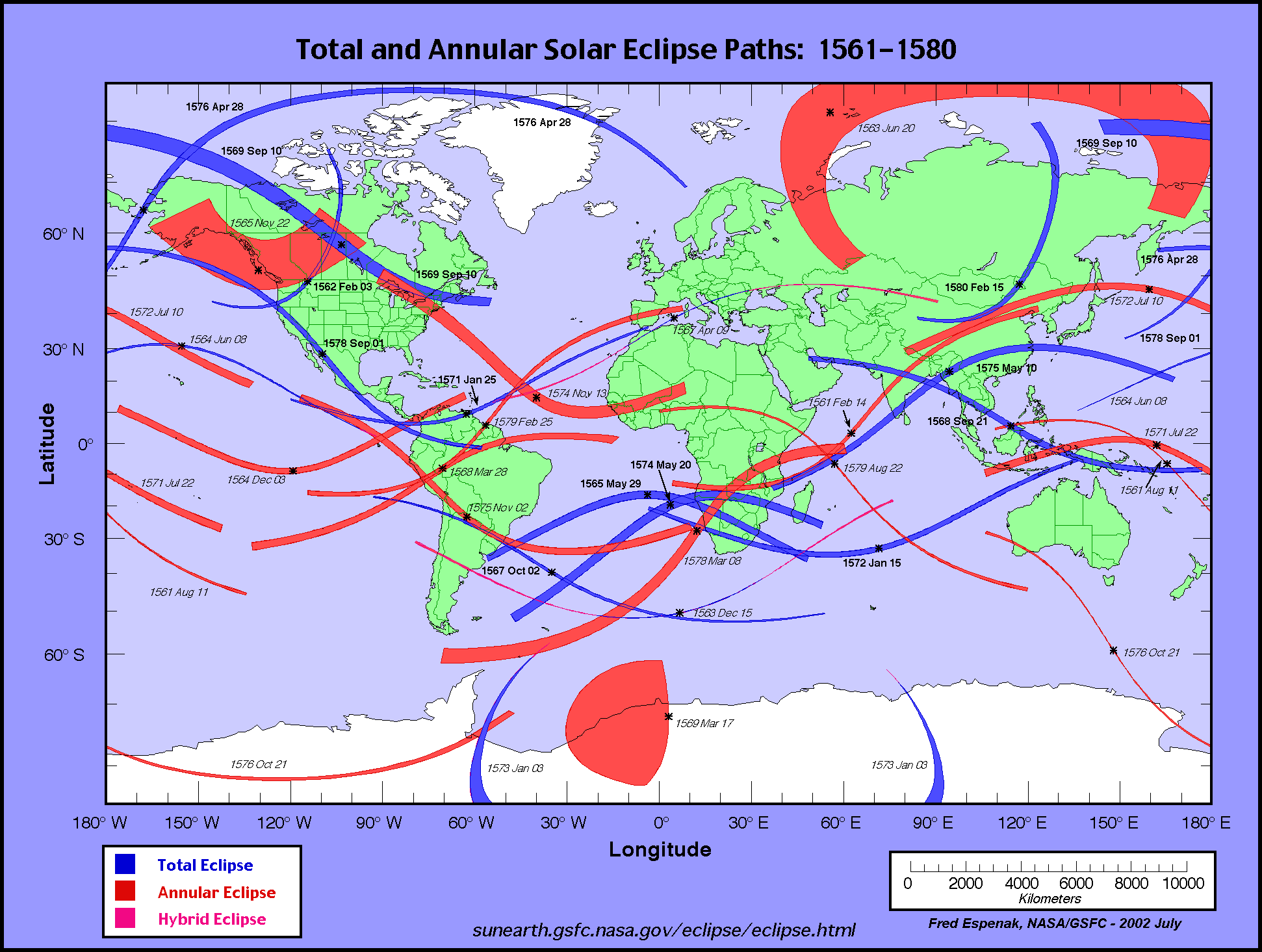
February 03, 1562 AD, total solar eclipse passed very close to Canada's Stonehenge if it did not pass directly over it and less than for years later the southern edge of the path of the
November 22, 1565 annular eclipse passed over it.
http://eclipse.gsfc.nasa.gov/SEatlas/SEatlas2/SEatlas1561.GIFThe very thin path of totality of the
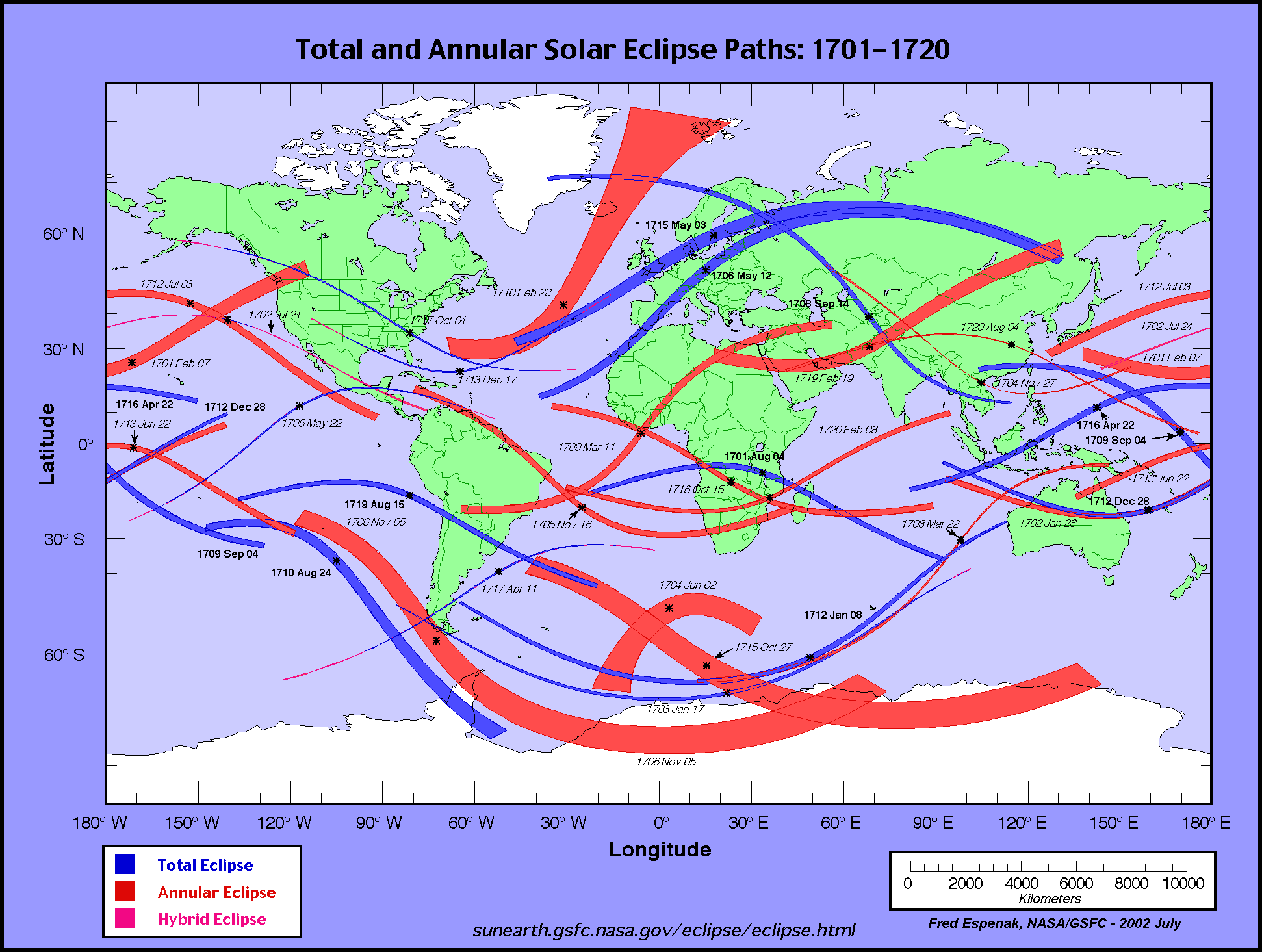
October 04, 1717 AD, hybrid eclipse passed within a hair's breadth of Canada's Stonehenge if it did not pass directly over it.
http://eclipse.gsfc.nasa.gov/SEatlas/SEatlas2/SEatlas1701.GIFThe POT of the
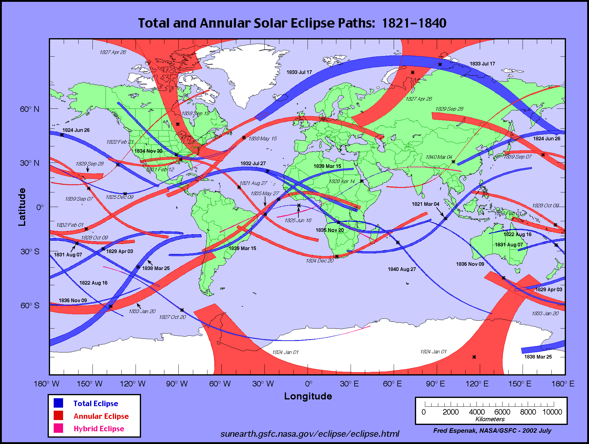
November 30, 1834 AD, TSE passed to the west of Canada's Stonehenge.
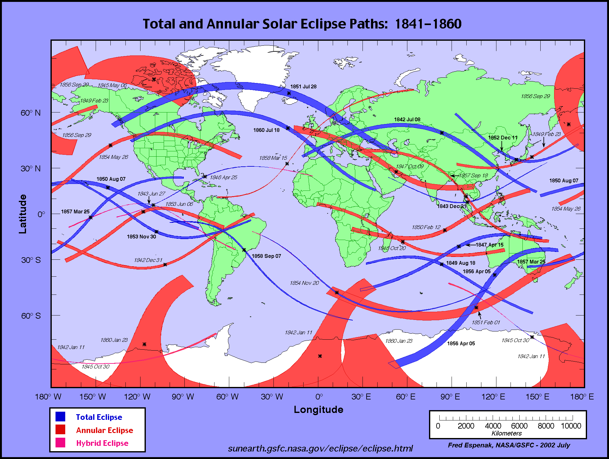
http://eclipse.gsfc.nasa.gov/SEatlas/SEatlas2/SEatlas1821.GIFMay 26, 1854 AD, annular eclipse would have been seen over the Majorville sun effigy and the POT of the
July 18, 1860 AD, TSE was directly overhead or not far from it.
http://eclipse.gsfc.nasa.gov/SEatlas/SEatlas2/SEatlas1841.GIFLess than a decade later Canada's Stonehenge would have been in the path of totality of the
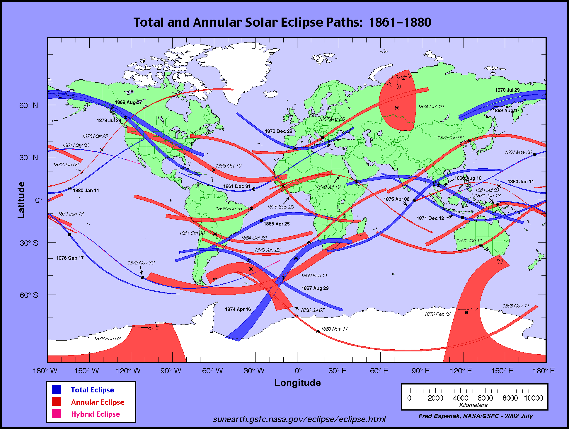
August 07, 1869 AD, total solar eclipse so it seems to me that it might be worth investigating the late 19th century lore of southern Alberta's First Nations people to see if these comparatively recent total solar eclipses had any influence on their beliefs.
http://eclipse.gsfc.nasa.gov/SEatlas/SEatlas2/SEatlas1861.GIFWas Canada's Stonehenge possibly still being used by them in the 19th century?
I will be in touch again soon Gordon but you have plenty to ponder here, along with various other things that I related during our phone conversation. Suffice it to say that I have very reasonable grounds to believe that "Canada's Stonehenge" may well have as much to do with eclipses as the original Stonehenge, and I haven't even touched on lunar eclipses yet.
Best Regards,
Robin Edgar


